Mountains, seagulls & upside-down waterfalls

Location: Holyhead, Anglesey
Days since departure: 56
Days walked: 50
Mileage: 748.5
Counties visited: 11
Blisters: 5 dead ones

OK, I give up – the blog isn’t going to catch up with me!

So instead, here’s a random snapshot of a couple of days from this week. You’ll have to check back once I’ve finished walking for some posts to fill in the gaps!

Bizarrely (anyone who knows me fairly well will agree) – I am actually on schedule with the walk. This means that, as planned, I started this week with a ‘discretionary’ stroll to the summit of the highest mountain in Wales, Snowdon. Not very coastal, I admit – someone I met in a cafe this week was relieved to hear that you don’t have to climb it as part of the Wales Coast Path – but it was a target inspired by my Dad. When out on a walk, if there was anything pointy within sight it was obligatory to climb it, so he wouldn’t have approved of me walking within 15 miles of Snowdon and passing it by.

Those who’ve been paying close attention to my itinerary & tracker may have spotted that I’ve started swapping my rest days from Friday to Saturday over the past few weeks. This means that I get to spend my rest day with Tasha, who comes up on Friday evenings to join me, rather than on my own.

On that basis, instead of resting in Caernarfon on Friday, I walked up to Pen-Y-Pass in the rain – about 13 miles, all on roads and mostly with no footway. A couple of miles outside Llanberis I bumped into a couple of very wet, knackered-looking law students from Bristol Uni (where I studied Aeronautical Engineering a few years ago). They were hoping to walk from Bangor to Abergavenny in about a week, including climbing Snowdon on the way. Both were carrying massive rucksacks that must have weighed about 80 lbs each – “It’s just the bare essentials, we took out everything we couldn’t manage without.”

I dispensed a little bit of advice (“please God no – you’ll end up needing Mountain Rescue”) when it transpired that they were planning to tackle Snowdon via the Horseshoe route (the hardest way, including the knife-edge of Crib Goch which has a boot-width path on uneven rock and sheer drops on both sides) – and that the only map they had between them was an A-Z.

I was really chuffed that my good friend, beard culturist and lime-green leotard owner Richard Nelmes made the long trip from the fine city of Stoke to join me for the Snowdon climb. We met up in Llanberis on Friday, and walked together to Pen-Y-Pass, where Tasha picked us up. The weather was, frankly, horrendous – it was chucking it down with rain and so windy that we actually had trouble standing up in places. Towards the top of the Llanberis pass it was pretty surreal to watch waterfalls where the water never reached the ground – as soon as it went off the edge, the wind threw it vertically back up the hill again! We warmed up a bit afterwards with a hot chocolate in the famous Pen-y-Gwryd hotel.

As planned, I then had my rest day (comprised mostly of laundry, lunch and trying to get my new phone working) on Saturday while Rich went out with his video camera to capture some footage of the Glyders, which he’s planning to use in his audiovisual compositions. We met up for some dinner in the evening at The Heights in Llanberis.

On Sunday, Tasha drove us both to Pen-Y-Pass and we took the Miners’ track to the summit of Snowdon. The weather was still rubbish – fortunately not so windy, but above about 600 metres there was zero visibility. We took things at a moderate pace and I was really surprised to find myself not feeling particularly tired at the summit – first time that’s ever happened to me on a mountain! Those 650 miles of walking beforehand must have done me some good 🙂

We walked back down the Snowdon Ranger route (on the opposite side of the mountain) – luckily the cloud was starting to lift so we had a fairly good view for most of the way down. Rich and I parted ways at the Snowdon Ranger youth hostel and then I walked all the way back to Caernarfon on the road, ending up at Bron Menai guest house – thanks to Mrs Ashcroft for her kind welcome.

On Monday I crossed the Menai suspension bridge to Anglesey – it’s bigger than it looks on the map (Anglesey, not the bridge). Now I’m about half-way round, at Holyhead. The weather has been mixed but I had a little boost on Thursday when Arry Beresford-Webb joined me for a stretch between Wylfa and that pointy bit before you head south towards Church Bay. When we met up she was lost as usual – we had a surreal phone conversation that went something along the lines of:

Arry: “How far have you got?”

Me: “I’m at Cestyll.”

Arry: “Oh cool, I’m really close to there”

Me: “Hang on, are you wearing black, I think I can see you?”

Arry: “Yep, I can’t see you though”

Me: “I’m wearing blue, waving my walking poles”

Arry: “Still can’t see you”

Me: “To the left of the three seagulls! The ones that are flying!”

(Doh!)

Big thanks to Arry for not only keeping me company across the dreaded pebble causeway at Club Bar Bay / Squashed Baguette Bay / Arry Bay (other geographical terms may apply), but also for bringing another emergency supply pack including Penguins and a couple of Go Bars (for Offa’s Dyke). Arry and her massive feat of endurance have given me a huge impetus to complete my own challenge, and I’m honoured to have her as a friend.

Another update! (Don’t get too excited – it’s still a month out of date!)

Location: Newport, Pembrokeshire
Days since departure: 29
Days walked: 25
Mileage (planned): 363
Mileage (actual): at least 391
Counties visited: 7
Blisters: 5 – but they’re not hurting any more… fingers crossed!

OK, so (remarkably) it turns out I can walk faster than I can write. This blog is essentially a month out of date – sorry! Still having major trouble with phone signal, it’s pretty much non-existent for much of the route I’ve covered so far. So I’ll do my best to recount things in some sort of chronological order, but you might have to wait until December for me to catch up with July!

Having brought the pack weight down to a manageable level, the first few days’ walk went well. The weather was kind over the rest of the weekend, and Tasha walked with me through Day 2, which took us as far as St Donats in the Vale of Glamorgan. On the way we met up with the Ramblers again – this time on their way around Barry Island in the opposite direction to us – and with Steve Webb (DragonWalk2012 – he’ll be following my route later this year but starting in North Wales) and his other half Liz. Steve knew where to meet me thanks to my tracker which has mostly worked very well – more on that later. We stopped for a photo outside that cafe off of Gavin & Stacey, cue (actually quite convincing) Nessa impressions by Tasha.

By this time I’d already had my first navigational mishap – I wandered a long way down Dock Road instead of staying up on the clifftop on the eastern end of Barry Island, and ended up having to backtrack from a dead end (up a steep hill). It did mean I got to tick off an extra lifeboat station though – I seem to be collecting them, along with lighthouses.

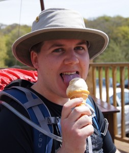
Next stop was Porthkerry Country Park, which has a great viaduct and an excuse for an icecream – first one of the walk!

Ice cream no. 1

Ice cream #1 - Porthkerry Country Park

Whilst I was eating this we got chatting to a family on the next table, who seemed really enthusiastic and donated £15! Set off feeling pretty positive about things after that!

We stopped next for lunch at Rhoose Point – the southernmost point of Wales and the first ‘-most point’ in the bag! Just west of here there’s some gravel pits where someone has made lots of swirly patterns in the gravel – you can see them on Google Earth.

A bit further west again is the power station at East Aberthaw. It’s a massive site and really dominates the skyline for a mile or so; it also has a pretty substantial sea wall and quite a lot of what I guess must be World War II remnants nearby – tank traps and pillboxes on the pebble beach. Probably one of the best defended power stations in the UK – if Dorset decides to invade I suggest an amphibious landing at Barry Island instead…

Unfortunately we encountered an even more effective obstacle at Gileston Farm, just inland from Aberthaw. The marked (and published) Wales Coast Path route passes through the farm and along a track through fields to the west – this saves a long walk over the enormous pebbles on the shoreline, which are pretty hard going. When we got into the farm yard we were nabbed by a farmer in a tractor who insisted that the correct route was back down the road and along the beach.

“Where do you think you’re going?”

“Along the Wales Coast Path, hopefully. We followed the waymarker over there.”

“Nah, it’s not that way, and anyway, you won’t get through cos it’s knee deep in s#*t.”

After the tractor disappeared, another younger and more helpful farm bloke turned up and admitted that, yes, the path does go that way, but “we’ve got a problem with it and it’s, er, a bit mucky”. He gave us some pointers about following the hedge through the field rather than on the track, and headed off too.

Out of the farm yard and into… slurry. Literally a foot deep, black and stinking, and running in a deep tide across the entire track and out through the hedges into the field for about 100 yards. Even with some carefully thought-out detouring, we couldn’t avoid all of it and had to wade through for a few yards – fortunately it didn’t quite come over the tops of our boots, but they were completely covered afterwards.

I won’t speculate as to how it got onto the track, except to say that we saw no sign of a slurry tank (leaky or otherwise) anywhere near the route…

The rest of the day was less eventful and at the end of it we were generously accommodated in a flatlet at UWC Atlantic College, who had also allowed us to park Tasha’s car there for a couple of days so that she could get home afterwards! The college, which teaches the International Baccalaureate to students from around the world, is based in a fantastic 12th-century castle and places a strong emphasis on community service – including having its own RNLI inshore rescue boat station which is manned by the students. The College and its founding headmaster Rear Admiral Dennis Hoare played a major role in the development of the Rigid Inflatable Boat (RIB) which is the most widely used type of inshore rescue craft.

As I’ve been writing this, I’ve been sat in Frankie & Benny’s in Carmarthen, taking advantage of the free wifi. Sadly time’s up as Tasha and I need to get back to north Pembs and zip up the tent before tonight’s forecast storms :-S

What am I doing in Carmarthen? Well, after a month of walking my first pair of boots has already given up on me, splitting at the toe flex point and letting in lots and lots of water – after a rainy day on Thursday my feet looked like I’d been in the bath all day! So we’ve popped back to Carmarthen on my rest day to pick up a replacement pair from the Cotswold store. Fingers crossed this pair will be a bit tougher! All credit to Scott at the Talbot Green store and to Tom at Carmarthen for making the swap completely hassle free  even though my receipt is back at home in Caerphilly – thanks chaps.

Next update as soon as I can manage it – thanks for your patience everyone!